Hormiguero Mayan Ruins. It is an area consisting largely by tropical forests in some areas are interspersed with savannah grass, watering and pantanos. La fundamental geological formation is limestone, because the soils are thin depleted after making continuous farming.
Rains are rainfed agriculture imitating the conditions of the latter, the vegetation is semi-tropical rain forest, where trees abound woods like mahogany, cedar and sapodilla.
The site is located in a slightly elevated area in the south and is divided into three main structure, neatly organized in a limited way (south, central and north).
Some rooms are small structures and inclosures, which were probably used for ceremonial purposes less.
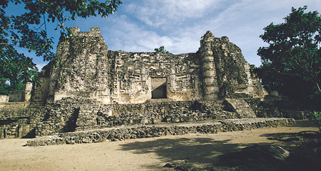
In the far north of the southern group, Structure II is elevated, and is possibly the most important building in the site due to their size and the forged memorandum to the main facade, the facade consists of three main sections divided by two towers rounded corners with steps simulated, typical of the Rio Bec style, although the temples crowning the ladder are atypical in the area because they are false, but not built more than four pillars that form a small attachment.
Door jambs of the entrances are formed by columns supporting lintels. The building stands on a base formed by three elements in the south, with two rooms in the building of the parties, and the roofs are on an access platform. Through two staircases on the sides of the central facade, you can access the building.
Structure V is located in the central group, it is a room of a building in eastern constrained by several elements that support it. Its north face has a mask similar to the structure II, but is smaller, and is bounded on its sides if the masks of Chac (the rain god in the Mayan culture), arranged in cascades.
Location.
Located on the southeast tip of the state of Campeche, 25 km southwest of X’pujil, in the municipality of Calakmul.